

UPDATE:
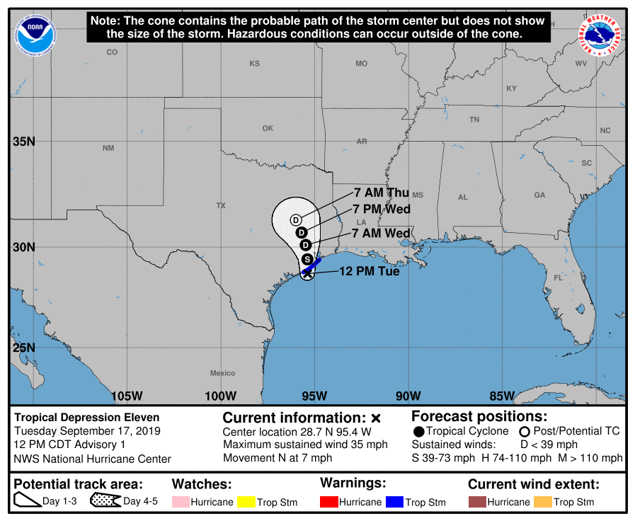
Tropical Depression 11 becomes Tropical Storm Imelda along the Brazoria coast near Freeport. This system will track slowly north-northwest over the next couple days.
PREVIOUS MESSAGE:
A Tropical Storm Warning is now in effect from Sargent to Port Bolivar. This will include the following coastal zones: coastal Brazoria county, coastal Galveston county (including Galveston island and Bolivar Peninsula), southeast Harris county.
This creates no real changes to forecast weather or impacts, expect locations in the warning could see sustained winds from 35-40 mph with higher gusts.
a Flash Flood Watch remains in effect from 1p today until 1p Wednesday, with heavy rain threat remaining greatest hazard with this system. General 5-10" rainfall is expected along and just east of the track with isolated higher amounts from 10-15".
WEBINAR INFO:
Webinar still on tap for 3PM today, September 17 to discuss the timing of heavy rainfall and any flooding or other impacts.
We will be using GoTo Webinar to display our briefing slides. You can register for the briefing at the following link:
https://attendee.gotowebinar.com/register/3204240068213279243
Webinar ID - 674-538-563
We will be using our own conference call phone system for audio. The call info is as follows:
1-866-228-9275
Conf Code: 5856690002#
If you have any questions, please do not hesitate to contact us.
Resources
- NWS Houston Galveston Phone Numbers: (281) 337-5074 ext. 234 or ext. 232
- NWS Houston/Galveston Webpage: www.weather.gov/houston
- National Hurricane Center Webpage: www.hurricanes.gov
- Hourly Forecasts (Click Your Location): http://forecast.weather.gov/gridpoint.php?site=hgx&TypeDefault=graphical
- West Gulf River Forecast Center Webpage: www.weather.gov/wgrfc
- AHPS Webpage: http://water.weather.gov/ahps2/index.php?wfo=hgx
If you have any additional questions, please feel free to contact our office at the phone numbers listed in the Resources section above.
Jeffry Evans
National Weather Service - Houston/Galveston, TX
Twitter: @NWSHouston
Facebook: NWSHouston