
Emergency Management is monitoring the situation, communicating with CMAC, and will continue to update the website with relevant information.
- A winter weather advisory is now in effect until 6 pm January 15.
- A hard freeze warning starts January 16 at midnight until January 17 at 9 am.
- A wind chill advisory starts January 16 at midnight until January 16 at noon.
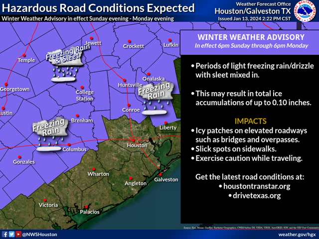
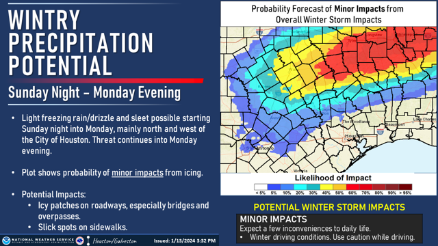
Light wintry precipitation, mainly freezing rain and drizzle, is affecting the Rice Community. Though impacts are expected to be relatively minor, they can still create hazardous situations if precautions aren't taken.
Use caution while traveling outside, be alert, and watch for slippery surfaces. Wear weather-appropriate clothing, a hat, gloves, and warm coats. Continue to monitor local media and the emergency.rice.edu website for developing conditions.
National Weather Service Overview
A surge of arctic air behind a cold front will result in several cold days this coming week, including bitterly cold temperatures, very low wind chills, and an opportunity for wintry precipitation on Monday. The result will be a band of primarily light freezing rain and freezing drizzle. As the colder air deepens late in the night into Monday, we may also see some sleet mix in.
In general, the overall ice accumulation is expected to be fairly light, less than a tenth of an inch across the area. However, even a light glaze of ice is capable of causing dangerous situations; take precautions if you must go out.
Though the precipitation and icing should end on Monday evening, this is only the beginning of several days of wintry conditions. Cold temperatures are expected to last deep into the week, with the coldest conditions expected Monday and Tuesday nights.
