Wednesday, September 18, 2019 - Rice University will be open for a regular class schedule and operations. For students, faculty and staff who have extended travel to campus or are dealing with difficult circumstances, please exercise your best judgement for your situation and communicate your decisions to your faculty adviser, college magister or supervisor.
The Crisis Managment Team will continue to monitor the weather and gather campuswide situational awareness of upcoming campus events/activities over the next 48 hours. Campus departments are taking the standardized steps to mitigate flooding and storm damage to campus facilities. Those traveling around campus and the city of Houston should carefully monitor the weather and Houston Transtar for road closures due to high water.
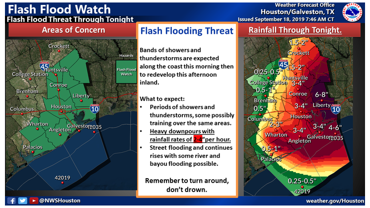
Remember, TURN AROUND, DON'T DROWN.
Please monitor this page for continued updates.
Recent National Weather Service Update:
Flash flooding threat continues across much of the area. Some areas in the coastal counties have received 5-19" of rainfall!. Particularly hard hit has been Matagorda county from near Midfield to near Bay City to Sargent much of that area has had more than 10-19 inches.
Rainfall rates of 2-4"/hour will be the main concerns today.
The heavy rains focused close to the coast should weaken this morning and redevelop further inland over the flash flood watch area. A band of storms will probably develop generally along the I-69 corridor this afternoon as the atmosphere destabilizes. Where the line redevelops is still in question but should help to focus more intense rains once it develops.
The heavy rainfall threat will continue tonight and into Thursday before gradually shifting northeast out of the region Friday.
As the ground becomes more saturated, increased rainfall runoff will be possible. These factors will play a big role in determining flooding impacts. We will provide updates as more information becomes available, but realize this situation could quickly change.
.....................
Marine - Elevated seas of 3 to 6 feet slowly subsiding this afternoon and tonight. Elevated tides of 1-1.5 feet above normal will continue leading to minor beach flooding and strong rip currents. Tidal currents in the ship channels will likely be very strong on the ebb tide Thursday.
Urban Flash Flood:
Heavy rainfall is forecast for portions of Southeast Texas, including highly urbanized areas like the Houston metropolitan area. Based on forecast conditions, NWS Houston will be utilizing the following urban flash flood messaging for this event:
- Turn Around, Don't Drown. Isolated underpasses or low-water crossings may be life-threatening.
- Monitor the NWS, your local media, HCFCD and other official weather information sources.
Next complete advisory at 1000 AM CDT.
Rice University Open 09/18/2019